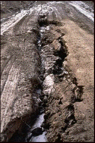
Erosion Potential Model
¥Displays
ÐErodibility of land in watershed
ÐPotential effect erosion has on water quality
¥
¥Accounts for proximity to the lakes and streams
¥
¥5 Input maps
ÐSoil
ÐSlope
ÐLand Use Type
ÐProximity to lakes
ÐProximity to streams
We also created an erosion potential model.  This model displays the erodibility of the land in the watershed and the potential for it to impact water quality.  The impact was determined by accounting for proximity to lakes and streams.  Erosion adds nutrients to the lake as the soil is swept away by runoff.  We used 5 input maps to model this.  Soil, Slope, Land use type, proximity to lakes, and proximity and streams.