�Objects in a layer can be represented by points, lines, or areas
(polygons)
�Layers can be overlain and manipulated
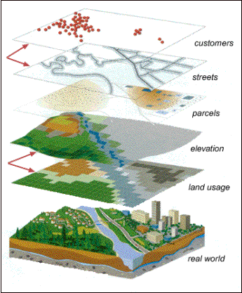
In GIS, each variable is
represented by a layer; this concept is illustrated in the figure.Each data layer represents a
different characteristic of the real world geographic area it is describing;
here, the data layers are land use, elevation, parcels, streets, and
customers.
Objects in a layer can be
represented in one of three ways: by a point, a line, or an area.In this example, the customers are
defined by points, the streets are illustrated by lines, and the parcels are
described by areas.
Layers can be overlain to
produce a wide variety of maps and images, and numerous analytical functions
can be used to answer questions about spatial relationships.