Togus
Pond Buffer
Strips


Inadequate buffer strips
are a problem
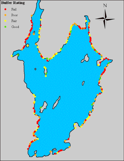
Buffer Rating
� Fail
� Poor
� Fair
� Good

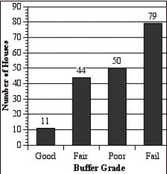
| We conducted a buffer strip
survey of every shoreline residence on September 16th. The survey categories included
qualitative measurements of lakeshore coverage, buffer depth, slope,
composition of shrubs and trees, and presence of rip rap on each
property. These assessments
combined to form an overall grade for each buffer. As you can see, failing buffer strips unfortunately made
up the largest category. This
buffer strip map shows the location of every buffer strip survey and the
color corresponds to its rating.
Red fail, orange, poor, yellow fair, and green as good. Arrows point to concentrations of
failing buffer strips that also correspond with areas of intense
development. The western shore
includes the steepest slopes in the watershed, and are not developed. Most of the shoreline lots have less
frontage than current regulations require. While a prime lake view is nice, failing buffer
strips are detrimental to water
quality and can be easily remedied by planting shrubs and trees and allowing
the natural vegetation to grow along the water. |