
Watershed
Description
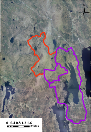
| For the purpose of comparing
the results of the current study to the one performed by CEAT in 1995, we
examined land-use patterns in both the direct and extended watershed of Long
Pond�s North basin. |
|
| The direct watershed, which
was recently defined by the Maine DEP, is all the land from which water flows
directly into Long Pond North basin without first entering another lake or
pond. The direct watershed |
|
| is outlined by the purple border. The extended watershed
was used in the 1995 study of Long Pond North and was included in this study
to more appropriately compare changes in land-use patterns that have |
|
| since occurred. In addition to occupying the land within
the purple border, the extended watershed encompasses the area in the
northwest corner which is defined by the red border. |