Study Objectives
�
Models
–
Used to understand
and estimate impact
of land
–
–
Septic suitability,
erosion potential,
phosphorus and
water budgets
Models SUCH AS THIS were used to show current trends within the watershed and can be used for predictions
The use of Geographic Information Systems was used to create maps through information gathered,
And other maps of the area to describe a desired characteristic
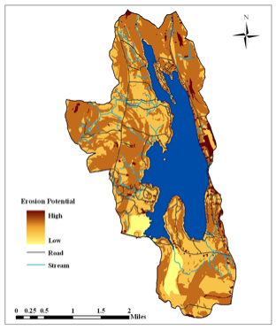
This map shows the erosion potential of the watershed and used information on soil type, land use, and slope
These maps are important in future projections as well as helping town officials in planning
for the watershed