|
|
|
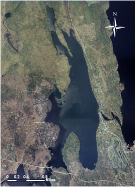
A Digital Orthophoto
Quadrangle (DOQ) is a computer-generated image of an aerial photograph in
which the image displacement caused by terrain relief and camera tilt has
been removed. The DOQ combines the image characteristics of the original
photograph with the georeferenced qualities of a map.
|
|
|
|
A georeferenced image is
integrated with geographical information that allows it to assume its correct
position once imported into a GIS program.
|
|
Useful since it seemlessly
integrates adjacent DOQs
|
|
This is the combination of 2
DOQs, the boarder between the two is found here� but once imported into the
program, they both assumed their correct positions, and formed this image.
|
|
|
|
Aerial photographs taken in
spring caused a set of tradeoffs�
|
|
The downside is that the lack of leaf-cover on deciduous
trees made it difficult to determine which areas on the DOQ were in fact
deciduous forest.
|
|
The upside is that since deciduous trees did not have
leaves, they did not obstruct other land-use markers such as residences and
roads.
|